Improving protection given to Priority Marine Features outside the Marine Protected Area network
A consultation seeking views on the scope of the project to improve protection given to PMFs outside the MPA network.
Annex B – Summary of socio-economic impact assessment methodology
The proposed methodology builds on previous marine socio-economic assessments undertaken for Marine Protected Areas. It takes account of Better Regulation Executive guidance on impact assessment, the Green Book methodology for economic assessment ( HM Treasury, 2011) and Scottish Government guidance on Business and Regulatory Impact Assessment ( BRIA).
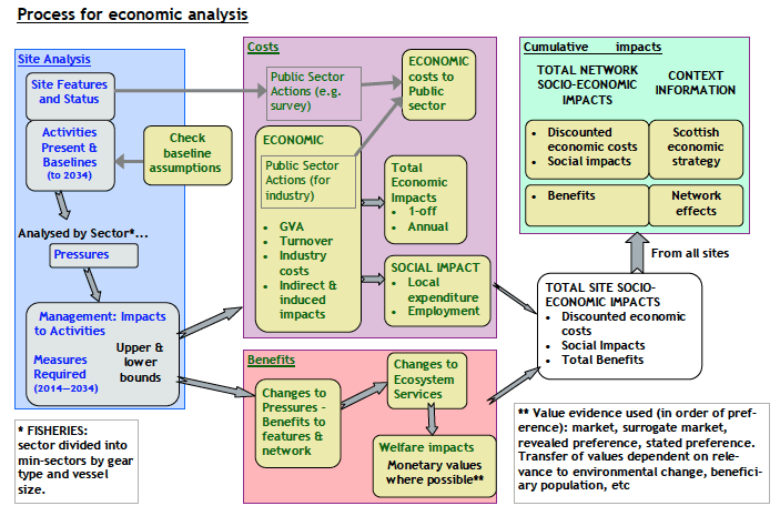
Figure 7 shows the process for economic analysis that has been used for assessments of Marine Protected Areas. As this project is expected to result in proposals for spatial measures then a very similar approach will be adopted. Some refinement may be required once the reasonable alternatives are identified.

Figure 7. Process for Economic and Social Analysis (from Marine Scotland, 2013a)
For the purposes of this assessment a number of assumptions have been made:
- Any management measures will be implemented during 2019 and costs will be first experienced in 2019. Costs and GVA impacts will be expressed in 2018 prices.
- An assessment period of 20 years following implementation of management measures has been selected as providing a reasonable time period within which the main impacts are likely to occur. The assessment period therefore runs from 2019 to 2038.
- Selected scenarios will be used to assess the potential range of impacts, which reflect a range of possible management options that may be applied and the potential for displacement of fishing effort to result in landings that compensate for the landings affected (see Section 3.4). Any scenario assessed may not reflect the final measures implemented by the Scottish Government.
Baseline information is compared against intervention options. Requirements for the baseline include:
- Information on the current spatial distribution of fishing in the marine environment, its intensity and economic value (turnover, GVA);
- Information on how the spatial distribution of activities in the marine environment and their intensity and economic value may change over the time period of the assessment (in the absence of the intervention), in response to existing drivers including current policy drivers;
- Information on ecosystem service values associated with the marine environment and how these may change over time (in the absence of the intervention);
- Processed Vessel Monitoring System ( VMS) data for fishing vessels over 12m in length, by gear type (demersal and shellfish landings only) for the period 2012–2016;
- ICES rectangle landings data for fishing vessels under 12m in length for the period 2012–2016;
- Scotmap data for fishing vessels under 15m in length.
Assessing the potential impacts of the different scenarios follows a systematic process. The following steps to assess the potential impacts on commercial fisheries are envisaged:
- Estimating the costs arising from the different scenarios.
Due to the differences in data availability, this will be carried
out separately for under-12m and over-12m vessels.
- For under-12m vessels, the value of landings affected would be calculated from the value of landings reported at ICES rectangle level, pro-rated based on Scotmap. From Scotmap, for each ICES rectangle, the value of landings from within potential management area will be calculated, as well as the value of landings from the ICES rectangle. The ratio between the two will be used to pro-rata the baseline ICES rectangle landings data.
- For over-12m vessels, Vessel Monitoring System ( VMS) ping data linked to landings records will be used. Recorded landings in a day will be allocated across all VMS fishing pings on that day, where a ‘fishing ping’ has been defined as one where the average speed since the previous ping is greater than zero and up to 5 knots for all gear types. The ping data will be then intersected with the management areas to calculate the value affected for each gear type.
- For both under-12m and over-12m vessels, landings values will be uprated to 2018 values using GDP deflators and averaged over five years (2012-2016) to provide annual average values over the period.
- These results will then be converted into Gross Value Added ( GVA) using fleet-segment specific ratios calculated from Seafish economic data. Further analysis will also assess effects on the supply chain, household consumption and effects on employment.
- The present value of impacts over the assessment period will be calculated. The average annual value of landings affected is assumed to be constant throughout the 20-year period of the assessment. Costs are calculated in 2018 prices, discounted over the assessment period at a rate of 3.5%.
- Finally other non-quantified costs and benefits will be documented, along with social impact and distributional analysis, and any Public Sector costs.
Contact
- Marine Conservation team
0131 244 1617
There is a problem
Thanks for your feedback