Scottish Marine and Freshwater Science Volume 5 Number 18: Depth use and movements of homing Atlantic salmon (Salmo salar) in Scottish coastal waters in relation to marine renewable energy development
Report describing the depth use of homing Atlantic salmon caught and released on the north coast of Scotland, recorded over 1-20 days using pop-up satellite telemetry during the summers of 2013 and 2014.
Results
Overall, 127 of the 135 tags deployed provided depth data (47 in 2013, 80 in 2014). However, tags with fewer than 200 depth records were excluded from subsequent analyses, leaving a total of 117 salmon with reliable depth records (43 in 2013, 74 in 2014).
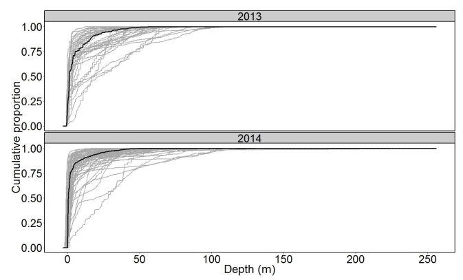
All salmon performed some diving activity. The mean maximum dive depth was 66.7 m (range 13.4-256 m). The cumulative depth distributions in 2013 and 2014 are shown in Figure 1 and were similar between years. Salmon were predominantly surface orientated. The median proportion of time spent in the upper 5 m was 80.4%, although there was considerable variation among individuals (range 8-99%, inter-quartile range ( IQR) 67.5-88.5%). In contrast, the median time spent at depths >20 m was only 6.7% (range 0-62 %, IQR 3.0-16.4%). Summary statistics of the proportion of time spent in 5m depth classes are provided in the appendix. Overall 122 of 135 tags provided a pop-up location (45 in 2013 and 77 in 2014), with 26 of these from rivers (6 in 2013, 20 in 2014). A total of 50 marine locations had an error <25km (28 in 2013 and 22 in 2014; Figure 2). The mean error associated with the marine locations was 7.6 km (7.2 km in 2013 and 8.1 km in 2014). The marine pop-up locations indicate movements in all possible directions from the release point, and up to 190 km off shore, though with a predominance of coastal locations.
Figure 1 Cumulative frequency of swimming depths for Atlantic salmon in Scottish coastal waters in summer 2013 (upper panel, n=43) and 2014 (lower panel, n=74). Thick line indicates median, thin lines represent individuals.

Five salmon were located within 25 km of the release site after 5-10 at sea (Figure 2), while one individual (identified by an individually numbered Carlin tag that remained attached to the fish post pop-up) was re-caught at the Armadale netting site 26 days after being initially tagged there, having travelled 90km to the coast of Orkney in the meantime, implying that at least some of the fish sampled made somewhat peripatetic movements. Meanwhile some other salmon reached distant rivers in a relatively short period of time, implying more directed migration. Twenty six tags were released in rivers of the north and east coasts of Scotland: there were no pop-up locations in west coast rivers (Figure 2). A higher proportion of tags in 2014 entered rivers, reflecting the longer programmed deployment periods: 10% of fish with ≤ 5 day deployments and 33% of fish with 15-20 day deployments were known to enter rivers.
Contact
There is a problem
Thanks for your feedback